The Zagros Mountains
The great mountain range that defines the Kurdistan Region of Iraq — a world of snow-capped peaks, deep gorges and wildflower valleys, from the high summits near the Iranian border to the ridges that frame its cities.
An overview of the Zagros
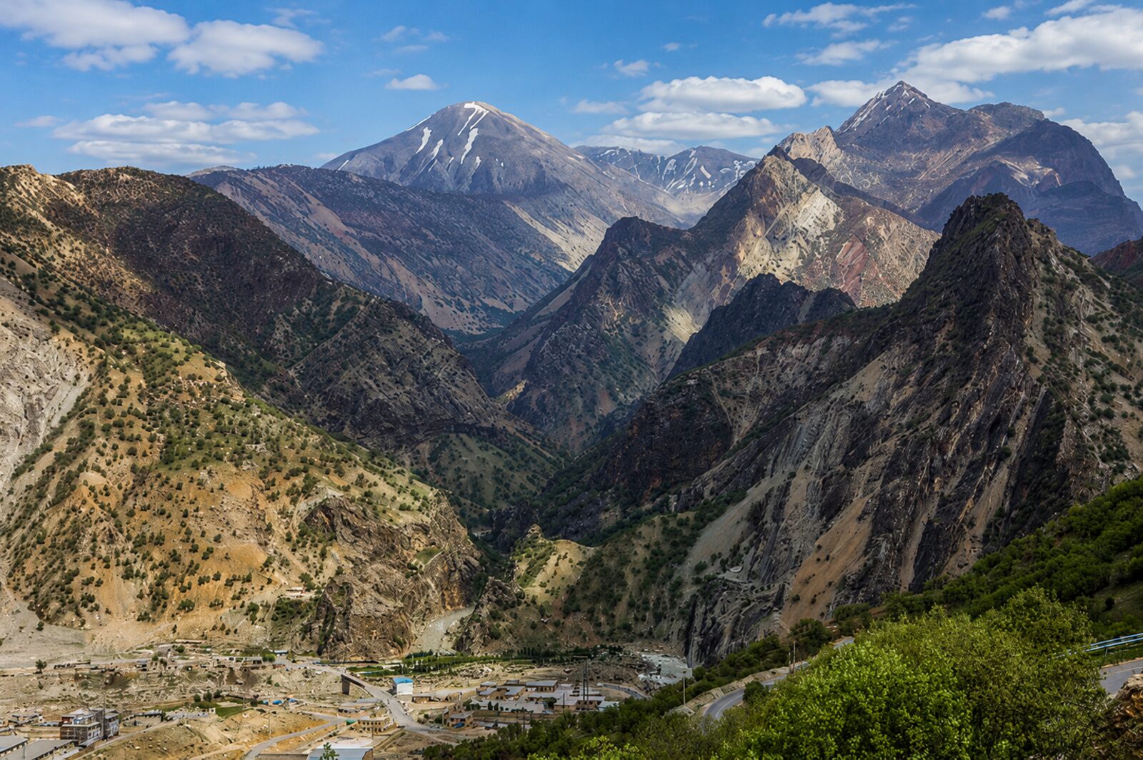
The Zagros is one of the great mountain systems of the Middle East, a long chain of folded ridges and valleys that runs along the eastern and northern edges of the Kurdistan Region of Iraq and continues across the border into Iran. More than any other single feature, these mountains define the region: they set its climate, shelter its villages, feed its rivers and shape a culture that has long looked to the high country as both a refuge and a homeland.
For travellers, the Zagros offer extraordinary variety. In spring the lower slopes erupt with green grass and wildflowers, creating the classic imagery of Kurdistan; in winter the highest peaks are buried in snow. Between these extremes lie oak woodlands, deep limestone gorges, tumbling waterfalls and quiet upland meadows. This guide walks through the major peaks and ranges worth knowing, from accessible summits reached by cable car to the serious mountains that draw experienced trekkers.
Major peaks and ranges
Halgurd Mountain
Near Choman, Erbil GovernorateRising over 3,600 metres in the far north-east near the Iranian border, Halgurd is among the very highest summits in the Kurdistan Region of Iraq and the undisputed prize for ambitious trekkers. It stands within the Halgurd-Sakran area, a cluster of high peaks and deep valleys that forms the most genuinely alpine corner of the region, where snow lingers on the upper slopes long after spring has greened the lowlands.
Reaching the summit is a serious undertaking rather than a casual day walk. Most ascents are made in the summer window, roughly July to September, once the snow has retreated enough to make the upper sections passable. The route involves long days, significant altitude gain and unpredictable mountain weather, so good fitness, proper equipment and acclimatisation all matter. Because the mountain sits close to the border, this is also an area where a knowledgeable local guide is strongly advised — both for route-finding and for current safety information.
The reward is a wild, glacial-feeling landscape of rock, scree and snow patches, with enormous views across the surrounding ranges. For experienced mountaineers it is one of the standout objectives in the country, but conditions, access permissions and the state of approach tracks change from year to year, so always confirm the latest situation locally before committing to a climb.
Korek Mountain
Above Rawanduz, Erbil GovernorateKorek is the most accessible of the region's high mountains, and for many visitors it is the easiest way to experience big mountain scenery without a demanding trek. A cable car climbs from the valley floor near Rawanduz up the mountainside, lifting passengers through changing bands of vegetation to a resort area high on the slopes. The ride itself is a highlight, with the dramatic gorges around Rawanduz opening up beneath you as you rise.
At the top, the air is noticeably cooler than the lowlands even in high summer, which makes Korek a popular escape during the hot months. There are viewpoints, walking areas and basic visitor facilities, and the panoramas stretch across ridge after ridge of the Zagros. In winter the mountain takes on a different character entirely, with snow cover supporting a short skiing and snow-play season that draws families from across the region.
Because it pairs so naturally with the Rawanduz canyon and the nearby Gali Ali Beg and Bekhal waterfalls, Korek is easily combined into a full day of mountain sightseeing. Cable-car operation, opening hours, ski availability and prices all vary with the season and the weather, so it is worth checking current conditions before you set out.
Safeen Mountain
Above Shaqlawa, Erbil GovernorateMount Safeen is the long ridge that rises above the popular resort town of Shaqlawa, a comfortable drive north-east of Erbil. Its accessibility makes it one of the most rewarding mountains for casual hikers and day-trippers: you can be standing on a high, breezy ridgeline within a couple of hours of the city, looking out over a patchwork of orchards, vineyards and red-roofed houses in the valley below.
Spring is the mountain at its best, when the slopes turn vivid green and wildflowers spread across the meadows. The ridge offers a range of walks, from gentle strolls near the top of the road to longer outings along the crest, and the elevation keeps things pleasantly cool when the plains are baking. Shaqlawa itself, with its cafés, fruit stalls and summer-resort atmosphere, makes a natural base for exploring the mountain.
Safeen is well suited to travellers who want genuine mountain views and fresh air without the commitment of a high-altitude expedition. As always in the Zagros, weather can change quickly and some upper tracks are rough, so sturdy footwear, water and a check of local conditions are sensible before heading up.
Azmar and Goizha
Above SulaymaniyahAzmar and Goizha are the twin mountains that form the dramatic backdrop to Sulaymaniyah, rising directly behind the city and defining its skyline. More than just scenery, they are woven into the daily life of Sulaymaniyah's residents, who head up their slopes to escape the summer heat, watch the sunset and gather for evening picnics as the city lights begin to glitter on the plain below.
A switchback road climbs Azmar, making it easy to reach viewpoints by car, and the route is especially popular in the cooler evening hours. From the heights, the whole of Sulaymaniyah spreads out beneath you, framed by the surrounding ranges — a view that is at its most magical at dusk. Goizha, its companion peak, offers similar vistas and is a favourite with local walkers and weekend visitors.
Together the two mountains function as the city's great natural balcony and outdoor living room, busy with families, friends and tea-sellers on fine evenings. They are among the easiest mountain experiences in the region to enjoy, but the roads are winding and can be busy at peak times, so allow extra time and drive carefully, particularly after dark.
Pira Magrun
North-west of SulaymaniyahPira Magrun is a broad, imposing massif that dominates the skyline to the north-west of Sulaymaniyah, one of the most recognisable mountains in the area. Its bulk and height mean that snow streaks its upper reaches well into spring, long after the surrounding countryside has turned green, giving it a striking presence that locals know intimately and visitors quickly come to admire.
The mountain has long been a favourite with local hikers and nature lovers, drawn by its wildflower-strewn slopes, cold springs and the sense of wildness that comes with its scale. Routes onto the massif range from accessible lower walks to longer, more demanding climbs toward the heights, and the higher you go the more expansive the views become, reaching far across the valleys and ranges of the southern Kurdistan Region of Iraq.
Pira Magrun rewards those who treat it as a proper mountain rather than a quick stop. Weather can turn rapidly at altitude, snow can persist on the upper slopes into the warmer months, and tracks are not always marked, so come prepared with layers, water and sturdy footwear — and, for the higher routes, the company of someone who knows the way. Conditions vary through the year, so check locally before you set off.
Gorges, waterfalls and valleys
The Zagros are not only about summits. Over millions of years, water has carved the range's limestone into some of the most spectacular scenery in the region. The Rawanduz canyon slices a sheer-walled gorge through the northern mountains, often compared to a miniature Grand Canyon, while the famous Gali Ali Beg and Bekhal waterfalls thunder out of the rock nearby in spring. Hidden among the folds of the range are orchards, shepherds' trails, cold springs and ancient sites — including Shanidar Cave, high in the Bradost mountains, where Neanderthal remains made the site world-famous.
The same mountains feed broad rivers and reservoirs that offer a gentler side of the outdoors, from the Greater and Lesser Zab rivers to the wide expanse of Dukan Lake. For the full picture of the region's natural attractions, see our Mountains & Nature guide.
Visiting the mountains
How you experience the Zagros depends on the season and your appetite for adventure. Accessible spots like Korek Mountain, the mountains above Shaqlawa and the roads up Azmar and Goizha can be enjoyed on an easy day trip, while the high summits near Choman reward those with mountain experience and proper equipment. Spring and autumn are the finest times for walking; summer opens the highest peaks once the snow has melted; and winter brings a short skiing season to Korek.
A few words on safety: mountain weather changes quickly, so carry layers, water, sun protection and sturdy footwear even on short outings. In some border districts there is a residual risk from old landmines left by past conflicts, so never head off established trails without asking locals first, and consider hiring a local guide for remote or high routes — they add greatly to both your safety and your understanding of the landscape. Access roads, cable-car and ski operations, and trail conditions all change through the year, so always verify the current situation locally before you travel.
Frequently asked questions
Where are the Zagros mountains?+
What is the highest mountain in the Kurdistan Region of Iraq?+
Can you climb the Zagros peaks independently?+
When is the best time to visit the Zagros mountains?+
Keep exploring
Continue with our mountains and nature, best hikes, Rawanduz, Shanidar Cave and Dukan Lake guides, or plan your trip.
VisitKurdistan.com is an independent travel guide and is not affiliated with any government tourism board or official tourism authority. Mountain access, road conditions, cable-car and ski operations, and trail safety all change through the year; always check current conditions locally before you travel.